The UK government has declared that they are "ending The War On The Motorist". These are our correspondents' dispatches from the front lines of their policies.
South Gloucestershire are consulting on expanding road capacity, and to justify it they cite their Climate Emergency declaration and tell us that building roads will solve climate change.
As a local issue, I’ve written about it elsewhere. But it covers lots of themes that are really At War With The Motorist material: zombie road schemes, highways departments who have never yet seen a problem for which they won’t suggest building roads is the solution, no matter how absurd, and councils who sell you road building with the empty promise that it will be accompanied with investment in public transport, active travel or liveable neighbourhoods.
It’s on a new blog I’ve been trying out for local things, tentatively called Bristolize (I don’t really like the name or its associations, I just haven’t thought of a better one yet). The other posts on it so far are perhaps a little bit in the style of Crap Cycling & Walking Waltham Forest, and clearly starting it is inspired by feeling a little bit nostalgic for the 2008-12 era blogosphere and very jaded with the social media that killed it off. I’m not sure I’ll keep it up for long, but I might have fun with it for a little while.
A misunderstanding in the ’00s led cycling organisations to recommend against separating cycling from walking and aided the proliferation of bad shared use paths. We’ve made some progress towards correcting that mistake, but it lingers in Bristol’s covert cycleways.
For anyone who has been missing getting together for Infrastructure Safaris lately, here’s a reminder that I’ve put some on YouTube. The latest is about shared use and covert cycleways:
I won’t try to replicate the video exactly in written form, partly because the point of an Infrastructure Safari is to (virtually) ride along and see everything in context, but mostly because it largely covers topics that I and others have written about before.
Specifically, the infrastructure safari is about the variety of things that fall under the umbrella of “shared use” cycling and walking infrastructure, and how each of them in their own way create and exacerbate conflicts between walking and cycling by persistently bad design.
The early history of shared use, introduced as a quick and cheap way to convert pavements into “cycle tracks” at a time when it was assumed cycling was on the way out, I wrote about in 2012.
But there is one part of the story that I had thought had been written about, if not by me then by another blogger, but which now after some searching I fear perhaps hasn’t, and so maybe deserves a few words here. That is: the story of how design guidance and even cycling organisations came to endorse and encourage mixing walking and cycling rather than trying to keep the two separate.
For decades after their introduction, the norm for shared use paths was, to use the technical jargon, “segregated shared use”. This unhelpful oxymoron means paths on which cycling and walking are separated into their own space. This encompasses a great variety of designs, including those that have a proper cycleway and a proper footway alongside.
But in practice, the overwhelming majority of such paths were the crap facilities we know so well: 3 metre wide pavements and greenways with a white line painted down the middle creating a comically narrow space for each mode.
The design guidance for shared use paths, 1986’s LTN 2/86 and 2004’s LTN 2/04 specified the presumption should be in favour of separating the modes.
And that led to lots of problems. People inevitably can’t always stick to “their” side, but people also get territorial. Cyclists can’t really pass one another in 1.5 metres of space, so will use the walking side. Where sightlines are poor, this can mean last-minute evasive maneuvers. People walking together like to walk side-by-side, and groups especially spill over. People get distracted or lost in thoughts and don’t pay attention to a white line or subtle signage.
Studies started highlighting these problems with segregated shared use — particularly influential amongst them a study for the DfT by Atkins, which looked at a small sample of shared paths, all of them archetypal narrow crap facilities.
There was an obvious lesson to be learned from these studies: build paths wider than 3.0 metres, and with more robust separation than a white line. All of the conflicts were caused not by the modes being separated from one another, but by the fact that the modes inevitably failed to remain separated from one another in such narrow spaces.
And yet we managed to take away an entirely different lesson: that it is best not to bother trying to segregate shared use, just mix the modes. Cycling Infrastructure Design, the DfT’s 2008 manual for crap facilities, removed the presumption in favour of separation and introduced the idea that it may be better to mix. Sustrans moved towards mixing in the ’00s and adopted a formal position against separating modes in 2010, based on their experience with routes including the Railway Path. Meanwhile, the Atkins study led to the DfT replacing LTN 2/04 in 2012 with LTN 1/12, which emphasised mixing modes. These moves also influenced the decision of the Royal Parks to remove separation on their much wider (but still only paint-separated) paths in 2017.
To be fair, some of the studies and guidance attempted to be a bit more nuanced: suggesting that widening paths is important where usage is high, and that mixing modes is a solution where physical constraints on width are out of the designer’s control. But nuance has never had a place in practice. Every time a design guide has specified technical minimum standards, alongside pages of nuance about best practice, the result is that infrastructure gets built to the technical minimum standards. And so, for more than a decade, rubbish 3.0 metre wide shared paths have proliferated where once rubbish 3.0 metre segregated paths would have been the choice.
Things are changing. Last year’s LTN 1/20 swept away all the previous guidance, specifying proper cycle tracks in place of shared use pavements, and returning to a presumption in favour of separation of paths, but this time with proper guidance on their widths. Even Sustrans are very slowly and reluctantly accepting the inevitable and will be widening the Railway Path, even if they haven’t yet quite managed to shake off the dogma about mixing modes being a good thing.
But that leads to the other main point of the Infrastructure Safari: that when we build these proper cycle tracks and paths with separation, they need to be clear and legible to all. Covert cycleways will only perpetuate the conflicts that led to the big misunderstanding about separation vs sharing in the first place. Do watch the video if you’re interested in that story.
It caught my eye because I’m quite ready to be critical of Bristol. And I will be.
But first, some reassurance. These numbers are (a) just a levelling off after years of growth, (b) probably not representative of the real situation in Bristol, and (c) probably a load of rubbish.
The numbers come from the Department for Transport. Here’s how they look when plotted as an index relative to 2000, alongside motor vehicles (beware, truncated y axis):
So this “decline” should be seen in the context of cycling journeys still being higher in number than in the last decade.
But actually this probably isn’t the right data to even tell you whether there has been a levelling off. You might get a clue from the fact that this data puts cycling’s mode share at 1-2% in a city that claims several times that much cycling.
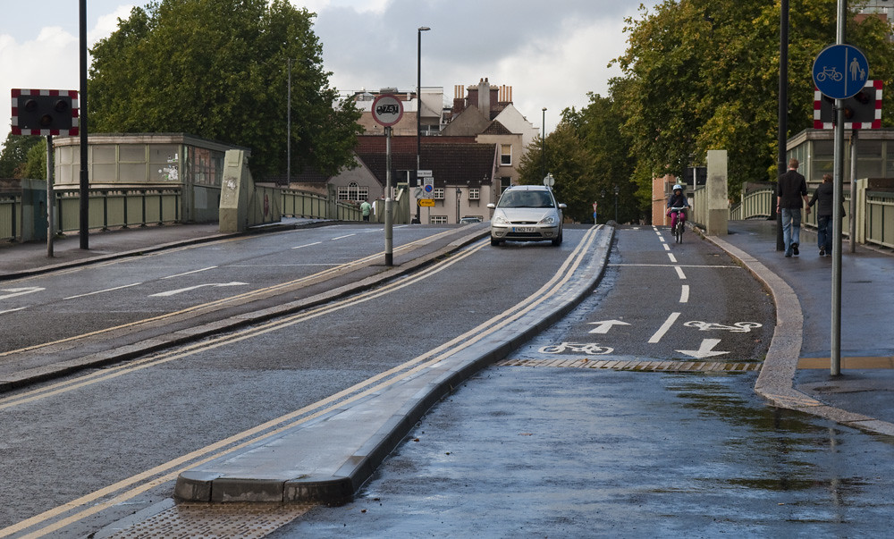
It’s because this is Department for Transport traffic count data, and the DfT only count on main roads. Roads like these:
The biggest, busiest and fastest roads in the city, including several where cycling is not even legal.
But Bristol’s strategy for cycling has largely neglected the main roads. (That is itself one of my criticisms of the city, but we’ll get to that.) Bristol’s rise as a cycling city is built on the foundations of its off-road routes on post-industrial corridors — the Railway Path, harbourside, greenways and towpaths. And in recent years its main policy developments have been slower speeds and filtered permeability on residential streets and in the city centre, as well as the development of additional joined-up off-road arterial routes.
So one could almost hypothesise that a fall in DfT main road traffic counts are what you’d expect to see in a city where the policy has been about creating alternative routes to the main roads.
Finally though, even for the dataset that it is, these numbers need to be taken with a big pinch of salt, because they are DfT traffic counts. The clue is in the fact that the line for cycling is really all over the place. These are based on a single day per year sample, probably collected by folk sat by the side of the road with pencils and paper, and so subject to big sampling noise.
Bristol had just voted to replace its ineffective council-led model of local government with the mayor-led model, and there were high hopes that the city might start seeing some progress after years of plodding along. Hopes were higher still when independent George Ferguson was elected later that year with a mandate for improving cycling in the city. Ferguson’s policies even promised to finally start addressing the main roads, and thanks to the volunteer-run Bristol Cycling Campaign, there’s even a network plan ready prepared to work through.
So three quarters of the way through his term, what have we got?
The Baldwin Street cycle track and the Clarence Road cycle track (2 years late and with the council instantly pandering to incompetent motorists by reducing its defences). Two very welcome schemes. But that’s three years for a kilometre of tracks, not even fully connected to the wider network. At this rate it will take centuries to complete the network.
But far more worrying than what hasn’t happened is what has. Bristol is still designing crap like this — and building it, despite the countless warnings they’ve received:
Busy, narrow, discontinuous shared use footways of the kind that should have been consigned to Crap Facility of the Month 15 years ago. This is not the stuff of a “cycling city”.
Bristol is still doing far better than — and doing nothing quite so embarrassing as — the likes of Birmingham or Leeds or Manchester, of course. But that should go without saying. That should go without saying. Bristol is expected to be better than Birmingham and Leeds and Manchester. But it’s certainly not exceeding expectations. It’s not moving forward or graduating from the low-hanging fruit of greenways to the hard work of fixing main roads. When London is building the NS/EW superhighways and many more kilometres of good stuff besides, nothing Bristol is doing looks exciting anymore.
And I think that’s because Bristol doesn’t appreciate what it has got, or understand how it got it. It has fallen for its own myth that it is an alternative city, and takes it for granted that the cool, green, self-reliant people of Bristol have a cycling culture. In fact, that culture arose alongside its off-road routes, and it could disappear just as quickly.
Worse even than the crap facilities on new roads is closing the Ashton Bridge for a year, severing greenway routes, to build a busway — diverting anyone who is left willing to cycle onto a dual carriageway. Or closing the Railway Path for months with similarly inadequate diversions. Over the past few years the city has variously proposed destroying the Railway Path entirely, destroying the riverside “chocolate block” path, and destroying part of the harbourside, all in the pursuit of mediocre bus systems serving the outer suburbs.
It is clear that council officers in the city have no appreciation of how absolutely critical these kinds of routes are — how dependent the growth in cycling modal share has been on them, how much they contribute to the city’s mobility, and how easily and how totally the city can be set back by allowing such routes to be destroyed. But outside the council there’s a complacency too. I don’t think many people quite appreciate just how critical the harbourside routes are, for example, because they exist by default as spaces left behind by industrial decline, rather than as something that had to be fought for, paid for, planned, designed and built. Yet they tie together the city’s radial routes in the centre — a vital function that other cities can struggle with immensely.
Bristol is still far better than Birmingham or Leeds or Manchester. But it’s not radical. And it needs to start taking its cycling infrastructure seriously. Because mode share can go down as well as up — and the fall can be faster than the ascent.
So the Institute of Advanced Motorists have press released the fact that casualties are up on 20mph streets (deaths are down, but they were already in single figures, so that’s random). I thought it might be worth reposting this sarcastic rubbish that I bashed out last time some idiot tried to claim that an increase in casualties on 20mph roads is evidence of their failure.
I heard on the lunchtime news on Radio 4 today the shocking news of an increase in the number of people injured on 20mph streets. Back when there were fewer 20mph streets, fewer people were injured on 20mph streets, they revealed. Now that there are more 20mph streets, more people are being injured on 20mph streets. This road safety intervention, they concluded, isn’t working.
This watertight logic perhaps also explains why BBC News have been so quiet on the destruction of the NHS. Before the NHS existed, literally nobody at all died in any of the then non-existent NHS hospitals. Almost as soon as the NHS was created, people started dying in the newly created NHS hospitals. Clearly the NHS doesn’t work.
Members of the Association of British Nutters will no doubt be getting very excited about these numbers, but before they make rash recommendations they should remember that back before the British motorway network was built, there were literally no people injured on the British motorway network, whereas now that the British motorway network exists, there are lots.
I hope that the main elements of the astonishing innumeracy that went into the BBC story — the failure to put the raw numbers into any kind of useful context, either of the rapid growth in the number of streets with 20mph limits as it has become easier to set the limit (or their changing nature as 20mph starts to roll out beyond quiet residential streets onto busier high streets), or of the far higher number (and, more importantly, rate) of injuries and death on either equivalent 30mph streets or on the same 20mph streets before the speed was lowered — should be obvious. Needless to say, reducing speeds on a street from 30mph to 20mph cuts injuries, regardless of the entirely banal fact that those few injuries which remain will thenceforth be added to the tally for 20mph streets instead of that for 30mph.
So, mockery over, there’s a more important point: should an increase in injuries, if there really had been one, automatically kill off further roll out of 20mph zones?
It beggars belief that the council intend reducing the 30mph speed limit. A limit introduced when there was no such thing as MoT’s, ABS brakes, crash zones on the front of cars and good street lighting.
I can see no justification in spending this money and would dearly love to know who Bristol City Council think it will benefit? It certainly won’t be the youth, disabled or elderly.
James R Sawyer clearly thinks that the 20 zones must be all about safety, as he argues that his ABS brakes and crash zones are already plenty enough to keep him safe as he drives through Bristol at 30. But Bristol have always been clearabout why they’re moving towards a 20mph city:
Councillor Jon Rogers, Cabinet Member for Care and Health, said: “…20 mph zones create cleaner, safer, friendlier neighbourhoods for cyclists and pedestrians. They are popular with residents, as slower traffic speeds mean children can play more safely and all residents can enjoy calmer environment.”
Slower speeds are not a simple issue of cutting crude injury statistics. They’re more about reviving communities which have been spoiled and severed by traffic speeding through them, reclaiming a little bit of the public realm that has been monopolised by the motorcar, and enabling liveable walkable neighbourhoods to thrive. Far from “certainly no benefit for the youth, disabled or elderly”, we know much — some of the research having in fact been carried out in Bristol itself — about the many adverse effects of higher speeds and volumes of traffic, and the loss of shops and services due to car-centric planning and living and the blight of high streets by arterial traffic, on the mobility of those most excluded from the car addicted society, particularly the young, the elderly, and the disabled. If they’re lucky, these people will be forced into dependency on those willing to help them get around; if they’re unlucky, they will simply be left isolated and severely disadvantaged. But of course, we don’t like to acknowledge the existence of the large numbers of people who are excluded from much of our society, culture and economy by our rebuilding the world with nobody in mind except car owners.
The injury statistics cited in the BBC News piece include minor injuries, which is most injuries at slow speeds — little things which don’t require a hospital stay. What are a few more cuts and bruises if it means that thousands of kids are free to walk to school with their friends instead of stuck inside mum’s car? Would we rather keep the infirm all shut up and sedentary with no access to the shops and the services they need, too intimidated by the anti-social behaviour of motorists to cross the road, than risk one person having a fall?
These strands can be tied together by the other piece of context that would have been worth including in the BBC piece: in the same year that injuries in 20mph zones increased, injuries to pedestrians and cyclists in general increased — in part because there are more to be injured. It has always been the case that the great road safety gains that successive governments have boasted of have been won mainly by making streets so dreadful that people find them too frightening, stressful, unpleasant, humiliating or ineffective to walk, cycle, or do anything other than sit in a secure metal box on. Start making the streets a little bit less awful and people return to them.
“The overall results show that ‘signs only’ 20mph has been accompanied by a small but important reduction in daytime vehicle speeds, an increase in walking and cycling counts, especially at weekends, a strengthening of public support for 20mph, maintenance of bus journey times and reliability, and no measurable impact on air quality or noise.”
The IAM make a thing of the DfT stats showing a 26% increase in serious injuries in 20mph limits and a 9% decrease in 30mph limits. Given that the base figures for the two sets are so different, that amounts to 87 more injuries in 20 zones and 1102 fewer injuries in 30 zones. Of course, the only figures that would really matter (in the absence of a double blind randomised controlled trial) are before/after comparisons of the streets that have switched and/or case-control studies of those streets (at least, for measuring injuries; as I said before, there are other important outcomes to 20 zones besides injury rates). And given that these numbers are not (and could not really be) normalised to the changes in total length of the two types of street, and are influenced by far too many confounding variables, I wouldn’t dream of suggesting that they’re worth drawing any conclusion from. But if you’re intent on drawing a conclusion, given the trend in switching 30mph streets to 20mph streets, a net reduction in serious injuries of 1015 seems like a far more pertinent one than a 26% increase in injuries on 20mph streets.
This time around, Rubberknickers Pickles is ending The War by lifting restrictions on how much of our town centres can be given over to car parking. The idea is nothing new, of course, but it is assumed that most will have forgotten the previous occasions when it was announced. The “news” is that the paperwork has gone through: the new version of the government’s planning rules are complete.
As far as I can tell, the notorious limits on car parking provision that have been dropped were Policy EC8, “Car parking for non-residential development,” in the Planning Policy Statement 4 of 2001 [PDF]. This policy instructs local authorities:
Local planning authorities should, through their local development frameworks, set maximum parking standards for non-residential development in their area, ensuring alignment with the policies in the relevant local transport plan and, where relevant, the regional strategy.
In determining what their maximum should be, the policy suggested that authorities think about the needs of non-car users, the effects of congestion and need to tackle carbon emissions and air pollution, and:
h. the need to make provision for adequate levels of good quality secure parking in town centres to encourage investment and maintain their vitality and viability
j. the need to provide for appropriate disabled parking and access
k. the needs of different business sizes and types and major employers
That is, the notorious Labour control-freakery over town centre parking was, er, an instruction for local authorities to develop guidelines that they think are suitable for their own local situations. The Policy document goes on to state that these local standards that authorities have developed should then be applied to planning applications — unless the planning applicant gives a good reason for them not to apply.
So these maximum limits are locally decided and not really binding. That doesn’t quite look like “centrally controlled parking quotas” to me. In his press release, Pickles says:
The Government believes councils and communities are best placed to set parking policies that are right for their area and based on local need – not Whitehall. Local people know the level of parking that is sustainable for their town centre.
Which seems to be exactly what the old Policy document supported.
Perhaps there was some other Labour policy, rule, or law that I haven’t been able to find? Anybody?
I’m not sure what real difference the removal of this policy makes. Previously councils were made to think about the effect of congestion and pollution and the like on their town centres, and the needs of people on foot and bike and bus. When a planning application came in they would know how to recognise whether it would be bad for their town, and they would have a good pre-prepared excuse to reject a development that would make their town centre a more congested and polluted place, or which would hinder walking, cycling, and public transport. But I assume that they’re still allowed to reject those developments if they still don’t like congestion and pollution and dead places?
But perhaps the new policy document will send a message to local authorities: your town centres are in a bad way, and you need to do something about it. In his press release, Pickles says that the removal of this rule will “provide a big boost to struggling high streets”:
The new draft National Planning Policy Framework, recently published, will do away with these anti-car restrictions introduced in 2001 and give high streets a boost to compete for shoppers. It will encourage new investment in town centres, provide more jobs and encourage more charging spaces for electric cars.
Unfortunately, Pickles doesn’t explain how the new Policy will translate into more competitive town centres with more jobs. More importantly, he presents no evidence to support the statement. So I went looking for it. Luckily, Greg Marsden has already reviewed the evidence on parking policies.
One of the studies that Marsden reviews is the 2002 Lockwood Survey, which divides “town centres” by size of the town/catchment area, and whose summary states:
4. Findings of the parking survey:
Major District Centres: Poor store performance is linked with low levels of parking, reliance on car parks more than 5 minutes walk from prime shopping streets and high charges (the report gives indicative levels).
Sub Regional Centres: Poor store performance is linked with reliance on car parks more than 5 minutes walk from prime shopping streets and high charges (the report gives indicative levels).
Regional Centres: Poor store performance is linked with high charges for 3 and 4 hour stays (the report gives indicative levels).
But when Marsden looked at the data he found it a lot more difficult to support these conclusions. In “major district centres”, those with very low levels of parking were indeed more likely to be performing badly. But those with mildly low levels of parking did better than those with high levels. And in regional centres, those with higher levels of parking were struggling more than those with lower levels. But those with very high levels of parking did a little better than those with very low levels.
There simply doesn’t seem to be any pattern in this data at all. The authors of the original report had cherry picked those parts of the data that made it look like low parking provision was harming shops, while ignoring those parts that said the reverse. Marsden found the same for parking charges and the proportion of parking spaces within a five minute walk of the main shopping area: the data was all over the place, showing no obvious and consistent relationship with economic performance. Why not? Because if variation in parking provision has any effect on town centre attractiveness and competitiveness at all, it is masked by far more important factors — perhaps factors like whether the town centre is easy to get to, has shops people want to use, and is a nice place to be.
So why is Pickles press releasing his new policy as the saviour for struggling town centres? Why did most of the newspapers toe that line? We’ve developed a national myth that giving over more of our town centres to parking is good for the businesses in them.
Sustrans documented the nature of this myth by talking to traders and shoppers on Gloucester Road in Bristol. Bristol is relatively dense and affluent with above average cycling and car ownership rates and, even by British standards, appalling public transport. Gloucester Road doubles as a major artery with many bus routes and a neighbourhood centre lined with mostly independent shops. As Bristol Traffic documents, its bus and bike lanes are usually filled with parked cars.
Not Gloucester Road, but a near-by case study which might teach us some things about why town centres are in decline
Shopkeepers on Gloucester road estimated that more than two fifths of their customers came by car. In fact it was only just over a fifth. They greatly underestimated how many people walked, cycled, or took the bus. The shopkeepers were perhaps being big-headed, believing that their businesses were capable of attracting people from a wider catchment area, when in fact most customers lived within an easily walkable distance.
And the shopkeepers greatly overestimated the importance of drivers to their business in another way: while the people who walked were likely to stick around and visit several shops and businesses, the drivers typically pulled up, ran in to one shop, and got out of there as fast as they could. Perhaps that’s because often they couldn’t even be bothered to park up properly and instead stopped in the bike lanes outside their destination.
High street shopkeepers and business owners greatly overestimate the importance of drivers to their success. Why? Perhaps proprietors are more likely to be drivers themselves, and, as is so often the case with motorists, can’t get their heads around the fact that so many others aren’t? Perhaps their view of the street through the big shop window is dominated by the big metal boxes passing through? Perhaps they see the apparent success of the big soulless out-of-town supermarkets and shopping malls, attribute that success to the acres of car parking, and leap to the conclusion that car parking is all that a business needs for success — that the model which succeeds on the periphery can be applied to the model that is failing in the centre.
I suspect that the opposite might be true. Those who are attached to their cars will go to the barns on the ring-roads. You won’t attract them back to the town centres. But by trying — by providing for the car parking at the expense of bike paths and bus lanes and wider pavements — you might drive away the surprisingly high proportion of town centre customers who don’t come by car, who come precisely because, unlike the malls, the town centre is walkable and cycleable and because the bus can get through. Town centres aren’t just competing with out-of-town malls and supermarkets any more. Those who don’t want to drive to out-of-town barns can sit at home, click on some buttons, and have things driven to them. Compared to most of the traffic-choked high streets in this country, that’s quite an attractive option.
Bristol is, I think — and have mentioned here many times — one of the top three least worst cities for cycling in the UK. They understand there that it is the danger and discomfort posed by motor traffic that prevents people from cycling, and it is their steady expansion and improvement to traffic-free routes that enabled a near doubling of cycle modal share for commuting since the 2001 census, to what is, by Britain’s risible standards, a relatively respectable 8%.
And this last week the city invoked jealous looks from the rest of the country on twitter when it opened the consultation on the latest in its long backlog of cycle network infrastructure projects: a proposal for what it describes as a “Dutch-style” bidirectional cycle track alongside a main road and the New Cut of the River Avon a little way south of the city centre. Not because the few hundred metres of cycle track are in themselves all that revolutionary, but because they saw a city quietly getting on with it, happy to replace car parking spaces with cycling infrastructure, and with little of the “Crossrail for bikes”-style hype.
So it should be a subject of great embarrassment for Bristol that at the same time as designing “Dutch-style” cycle tracks that take space from motoring on Clarence Road, it is finalising planning permission for the next Facility Of The Month alongside a big new ringway road — dressed up as a Bus Route — a couple of kilometres to the south.
The latest visuals of the South Bristol Link Road are strong contenders for the most ridiculous artist’s impression of a new road yet — and gosh does that prize have some competition.
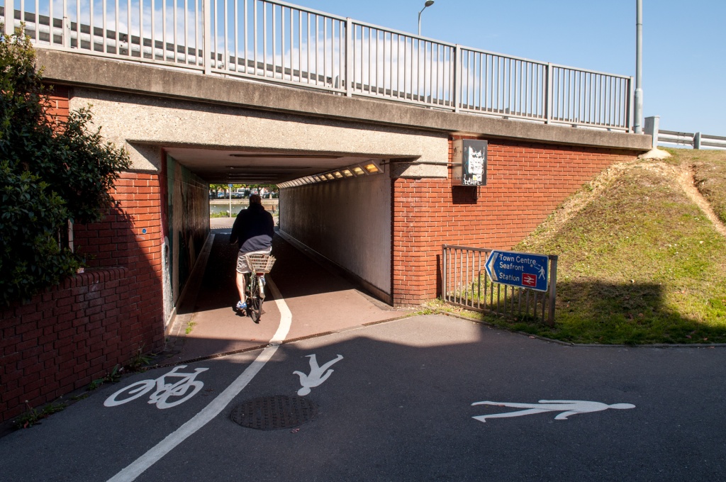
And amongst the wildflower meadows and sylvan glades of this new paradise, where morning motorists will no doubt be serenaded by songbirds as they speed uninterrupted through the city like they were promised in the car commercials, pedestrians and cyclists will be treated with utterly contemptuous shared pavements.
A nineties throwback, a footway with a white line down it, interrupted by every driveway and sprawling side-road. Straight out of the government’s Manual for Crap Facilities.
Elsewhere Bristol is learning the lesson that much of its first generation cycle infrastructure — the Railway Path, the quaysides, and many dozens of “fiddly little bits” documented in detail by Sam Saunders — is proving inadequate, victim of the city’s small success, as their insufficient capacity and lack of clarity creates conflict between users. Which is why the city is learning to build “Dutch-style” clear cycle tracks — Clarence Road being the latest of a series.
And it’s why it’s so galling to see a proposal for something not even up to standards of that first generation of infrastructure. A facility that is, at best, worthy of Birmingham or South Gloucestershire.
In writing up the Cycling Embassy’s AGM infrastructure safaris, I saidsomenicethings about Bristol. I think it’s the least worst city for getting around by bicycle in Britain. But despite the good things that Cycling England’s demonstration city project achieved, and the city council’s boasts about it, Bristol has failed to become a cycling city where it most matters.
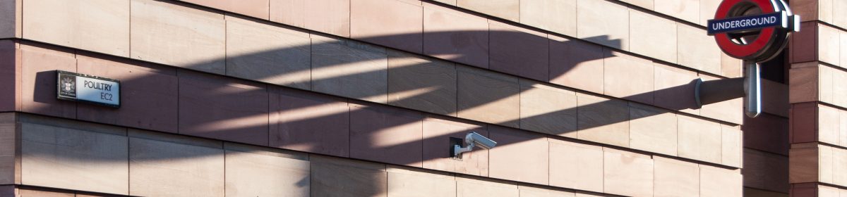
The city was named and shamed by The Times for one of the worst junctions in the country, the St James Barton roundabout — aka The Bearpit — on the inner ring road. Four lanes of circulating traffic forming a formidable barrier to getting into the city centre from the arterial roads that terminate here. But while one wing of the city council considers new variations on the Great British shared facility — awkward kludges to work around the mistakes and omissions of the 1960s — another is independently working on “public realm improvements” just yards away, each apparently oblivious to what the other is doing. And neither of them seems to have a clue that this is a “cycling city”.
Regular readers might already be familiar with the street that they wish to improve: the A38, one of those arteries terminating at St James Barton. It’s variously Stokes Croft, Cheltenham Road, and later Gloucester Road. It’s the artery explored in this infrastructure safari, and, a few miles up, the high street that was the subject of this post on how people get to their local shops.
Heading north out of town, if you survive St James Barton, you’ll need to turn onto the bus lane, underneath 51°02, onto Stokes Croft (technically North Street for the first hundred yards or so), and then try to dodge the buses which are overtaking you on the bend ready to immediately pull into the bus stop that’s hidden just behind 51°02’s stilts…
…while on the southbound carriageway a single lane widens into four for stacking at the roundabout, much having been bulldozed out of the way for them half a century ago. Continuing northbound, a section of extra-wide footway — spare space set aside when there were ideas that this road should one day be even wider — is mostly lifeless in this land of the motor…
…and finally, the section of sprawling highway ends abruptly where the old street dimensions and frontages survived the bulldozers… but suffered the years of planning blight from threats of road widening that left them in a poor state of repair and, when occupied at all, usually occupied by the city’s less wholesome businesses.
There’s no doubt that this is a pretty foul place for pedestrians, with a cloud of fumes coming off the four lanes of stacked traffic waiting for the lights; and the cars speeding around the blind bend from the roundabout; and the acres of dead space in the non-standard road layout that encourages non-standard manoeuvres. So the city council are consulting on “public realm improvements” for this area, hoping to bring the pavements alive with people and street cafes. So what are these improvements?
Taking out the bus lane to widen the footway, leaving cyclists with that thoroughly discredited facility, the 1.5m on-carriageway cycle lane, leading cyclists into exactly the same deadly conflict with the bus stop as before, and providing the ever delightful environment of buses pulling in and out inches to the left of you, speeding cars and trucks inches to the right of you.
And acres of dead carriageway replaced with acres of dead pavement, and again, that widely tried and widely failed 1.5 metre cycle lane, a gutter sandwich between traffic and the driver-side doors of the loading and parking bays. But it’s OK, the designers have thought about the needs of cyclists: the loading bays are supposedly “wide enough to create a safe buffer between car doors and passing cyclists”. And a raised table will apparently slow drivers down as they nudge the steering wheel slightly to turn across the cycle lane into that grossly distended side road, King Square Avenue, so that’s alright then.
No doubt the trees and fancy fashionable paving will make this a less awful place to be on foot, but I’m not sure people will be rushing to set up pavement cafes next to the totally unchanged four-lane stacked traffic. It’s treatment of symptoms without addressing the real causes of the problems here.
More to the point, it’s still useless if you’re on a bicycle, because, like everything built by the city’s highways engineers, it’s designed with Britain’s useless guidelines and rules. And that’s why Bristol’s authorities can not claim to be administering a cycling city. The great things that have been achieved in the city can be attributed to either the few excellent hard working cycling officers, or to the consultants and contractors bought in and guided by Cycling England during the demonstration city project. But the cycling office appear to have been put in a silo, able only to get paths put in where they won’t inconvenience anybody — through the parks, behind the allotment gardens, under the electricity pylons; and the hired expertise left when Cycling England and the demonstration city project went up in the bonfire of the quangos. The rest of the council seems to be as oblivious about cycling as any other authority in Britain: the highways department are as obsessed as any other with traffic flow and junction capacity; transport officers are just as obsessed with buses; parking enforcement just as powerless to keep cycle lanes clear; police just as indifferent to dangerous driving. It’s not a cycling city, it’s a city with a cycling department.
All of the candidates to be Bristol’s first mayor say they want to be in charge of a cycling city (even if one of them doesn’t mean it) and all of them recognise that there’s a way to go before they can claim to be so. If they’re to get there, they need all their officers behind them, not just the few in the cycle paths office.
I heard on the lunchtime news on Radio 4 today the shocking news of an increase in the number of people injured on 20mph streets. Back when there were fewer 20mph streets, fewer people were injured on 20mph streets, they revealed. Now that there are more 20mph streets, more people are being injured on 20mph streets. This road safety intervention, they concluded, isn’t working.
This watertight logic perhaps also explains why BBC News have been so quiet on the destruction of the NHS. Before the NHS existed, literally nobody at all died in any of the then non-existent NHS hospitals. Almost as soon as the NHS was created, people started dying in the newly created NHS hospitals. Clearly the NHS doesn’t work.
Members of the Association of British Nutters will no doubt be getting very excited about these numbers, but before they make rash recommendations they should remember that back before the British motorway network was built, there were literally no people injured on the British motorway network, whereas now that the British motorway network exists, there are lots.
I hope that the main elements of the astonishing innumeracy that went into the BBC story — the failure to put the raw numbers into any kind of useful context, either of the rapid growth in the number of streets with 20mph limits as it has become easier to set the limit (or their changing nature as 20mph starts to roll out beyond quiet residential streets onto busier high streets), or of the far higher number (and, more importantly, rate) of injuries and death on either equivalent 30mph streets or on the same 20mph streets before and after the speed was lowered — should be obvious. Needless to say, reducing speeds on a street from 30mph to 20mph cuts injuries, regardless of the entirely banal fact that those few injuries which remain will thenceforth be added to the tally for 20mph streets instead of that for 30mph.
So, mockery over, there’s a more important point: should an increase in injuries, if there really had been one, automatically kill off further roll out of 20mph zones?
It beggars belief that the council intend reducing the 30mph speed limit. A limit introduced when there was no such thing as MoT’s, ABS brakes, crash zones on the front of cars and good street lighting.
I can see no justification in spending this money and would dearly love to know who Bristol City Council think it will benefit? It certainly won’t be the youth, disabled or elderly.
James R Sawyer clearly thinks that the 20 zones must be all about safety, as he argues that his ABS brakes and crash zones are already plenty enough to keep him safe as he drives through Bristol at 30. But Bristol have always been clear about why they’re moving towards a 20mph city:
Councillor Jon Rogers, Cabinet Member for Care and Health, said: “…20 mph zones create cleaner, safer, friendlier neighbourhoods for cyclists and pedestrians. They are popular with residents, as slower traffic speeds mean children can play more safely and all residents can enjoy calmer environment.”
Slower speeds are not a simple issue of cutting crude injury statistics. They’re more about reviving communities which have been spoiled and severed by traffic speeding through them, reclaiming a little bit of the public realm that has been monopolised by the motorcar, and enabling liveable walkable neighbourhoods to thrive. Far from “certainly no benefit for the youth, disabled or elderly”, we know much — some of the research having in fact been carried out in Bristol itself — about the many adverse effects of higher speeds and volumes of traffic, and the loss of shops and services due to car-centric planning and living and the blight of high streets by arterial traffic, on the mobility of those most excluded from the car addicted society, particularly the young, the elderly, and the disabled. If they’re lucky, these people will be forced into dependency on those willing to help them get around; if they’re unlucky, they will simply be left isolated and severely disadvantaged. But of course, we don’t like to acknowledge the existence of the large numbers of people who are excluded from much of our society, culture and economy by our rebuilding the world with nobody in mind except car owners.
The injury statistics cited in the BBC News piece include minor injuries, which is most injuries at slow speeds — little things which don’t require a hospital stay. What are a few more cuts and bruises if it means that thousands of kids are free to walk to school with their friends instead of stuck inside mum’s car? Would we rather keep the infirm all shut up and sedentary with no access to the shops and the services they need, too intimidated by the anti-social behaviour of motorists to cross the road, than risk one person having a fall?
These strands can be tied together by the other piece of context that would have been worth including in the BBC piece: in the same year that injuries in 20mph zones increased, injuries to pedestrians and cyclists in general increased — in part because there are more to be injured. It has always been the case that the great road safety gains that successive governments have boasted of have been won mainly by making streets so dreadful that people find them too frightening, stressful, unpleasant, humiliating or ineffective to walk, cycle, or do anything other than sit in a secure metal box on. Start making the streets a little bit less awful and people return to them.
“The overall results show that ‘signs only’ 20mph has been accompanied by a small but important reduction in daytime vehicle speeds, an increase in walking and cycling counts, especially at weekends, a strengthening of public support for 20mph, maintenance of bus journey times and reliability, and no measurable impact on air quality or noise.”
Champion Square: shared space that works, because it’s combined with filtered permeability.
Finally, the Saturday evening Infrastructure Safari at the Cycling Embassy’s AGM in Bristol in May. This was led by Steve Melia, a transport and town planning academic at the University of the West of England and campaigner from the Carfree UK and Living Heart for Bristol campaigns. That latter campaign formed the theme for the safari, a short ride around the city centre looking at the big roads that blight it and the ways in which traffic reduction has already helped to make a more thriving liveable city, and the potential for further reduction.
The basic idea of the Living Heart campaign is to cut traffic and create a liveable city centre through the careful use of selective permeability to make it impossible to drive through the city centre, without preventing anybody who has a genuine need to be there with a vehicle — residents, traders, and deliveries — from driving in and out. In a sense, they are seeking to make the best of the Bristol that the motorway mad 1960s planners left us, with its arterial motorway and inner ring road, by switching from a system which used the big roads to feed ever greater volumes of traffic into the old city streets to one which uses those main roads to remove traffic from those streets. Or, to put it another way, they would block up the ratruns, freeing them up for more suitable and useful purposes.
Queen Square, before and after, from the Living Heart campaign.
Compared to much of the country (and I know, that’s hardly a ringing endorsement), Bristol already has a relatively good record on creating a liveable low-traffic city centre. It started in the 1980s with strategic road blocks and short sections of pedestrianisation to close ratruns in the Old Town, at King Street and Corn Street and the like, and continued in the Broadmead shopping area with (poorly enforced) bus-only streets coupled to one-way systems which enable access while making unattractive ratruns. More dramatically and famously, Bristol has succeeded in rolling back some of the mistakes of the motorway mad past: the inner “ring” road dual carriageway isn’t a ring any more. Where for decades it crossed diagonally through the fine Georgian Queen Square, blighting the area so that all around was neglected and run down, it was closed amid much protestation in the mid-1990s, and the square restored in stages through the 2000s, giving the city a much loved little park and thriving commercial zone. Similarly College Green outside the cathedral has lost a main road.
But the city centre still suffers from motorists trying to find a shortcut through the old streets, at times making them unpleasant places to be and to do business, and trapping pedestrians, cyclists and public transport users in the mess they create, not just fellow motorists. The campaign are not greatly attached to any one specific means of keeping this through traffic out of these unsuitable streets — there are lots of potential places where a block or a bus gate would be appropriate and have the desired effect. But they particularly point to the four bridges that cross the harbour within their ring road cordon as obvious places to consider.
And they have a good local example to cite. Unfortunately we were too busy looking at railway paths to look at the city centre while in Bath. At first sight Bath, with a perpetually jammed trunk road almost through the heart, would seem an unlikely choice for a lesson on liveable low-traffic city centres, but it would have been worth looking at for the ways in which many of the old city centre streets have been reclaimed from traffic while maintaining essential access: through road blocks with pedestrian and cycle permeability, a one-way system around the historic and commercial centre which enables access for delivery vans and then sends them back to the same main road they came in on, and, of interest to Living Heart, Pulteney Bridge bus gate. Together these things create some pleasant public spaces, some streets fit for cycling, and some bus routes not completely blocked by jams of ratrunning motorists.
Ultimately the Living Heart campaign, and Steve’s safari, is about segregation: separating traffic away from people. It’s what all of the diverse safaris in the Westcountry were ultimately about. Which will be explored properly in a post to conclude this whole thing. If and when I get around to writing it…
Another of the Embassy AGM Infrastructure Safari writeups. Shorter and not quite so nerdy: a scenic circuit of the lower section of the former docks in the evening sunshine, including a Victorian-era riverside shared path, a huge incongruous 1960s road system beside the Clifton Suspension Bridge viewpoint, and another example of Bristol turning roads into parks. The main point, though, was that the old quaysides and riverside paths, despite all their limitations, make usable and even pleasant (if you’re not in a hurry) cycle routes, linking up to the other traffic-free routes, and perhaps help to explain Bristol being that fraction better than the rest of the country at widening access to cycling.
I promised to write up the other infrastructure safaris that the Cycling Embassy took while in Bristol for the AGM in May. David Arditti blogging about the safaris prompted me to get on with it. Previously I showed you the Railway Path. Left to come are a couple of rough and rambling posts, accompanied by Google Earth infrastructure safaris, on Bristol’s arterial cycling infrastructure (below) and city centre streets, hopefully leading to the properly thought out post that will eventually get to the point.
So on the Sunday morning safari we looked at the options for utility cycling between the city centre and residential and commercial neighbourhoods in the north of the city.
As before, for the details, pictures (mostly Mark’s and David’s) and video, it’s recorded as a virtual tour to be taken in Google Maps or downloaded for Google Earth: here is the Google Map tour.
The basic context is that we rode from the city centre through 5km of residential neighbourhoods until we hit the outer ring road. The latter is late 20th century car territory — motorway junctions sending out tentacles of dual carriageway distributor roads to roundabouts around which car oriented commercial development grows. Much of the British aerospace industry, a major Ministry of Defence office, retail and logistics businesses, offices and R&D for tech companies, and a large university rise from a sea of car parks out here in the “North Fringe”, just outside the city boundary in South Gloucestershire, where the council allows that sort of thing. The route we were looking at was therefore one of important traffic flows: two centres of employment (and culture and retail and education) and the residential neighbourhoods they serve.
There are several different arterial routes serving this traffic: of road, rail and cycleway. We headed north on the original artery — the traditional main road, the A38 Stokes Croft/Cheltenham Road/Gloucester Road (turning off onto the lesser Filton Avenue for a shortcut). Just a normal British urban arterial ‘A’ road, 2 lanes + 2 bus lanes where room permits, dozens of buses in peak hours, car parking in the off peak hours, row upon row of shops and houses and little residential side roads. Occasional token painted 1.2m advistory cycle lanes, of no use to anybody under the parked cars.
We headed back on a new Cycling City funded cycle route, Concorde Way, on about 50:50 residential backstreets and 3.0-3.5m shared paths. The route is not bad. Nowhere near modern Dutch standards, obviously. There are a couple of little fiddly bits with toucans and pavements. There’s a street that’s used by motorists as a ratrun. There are paths as narrow as 3.0m shared between pedestrians and cyclists, despite this being a densely populated urban area. There are paths even narrower than that, briefly, where they reuse the 1970s subways under a motorway junction. There’s a new home zone built on a through trunk cycle route. I wish it were better, but I congratulate its designers for doing so well against all the odds, fighting the rules of British Highways engineering all the way. Aforementioned pinch points aside, it’s not too narrow, it’s not too slow, it’s not too unsafe, it doesn’t ever abandon you. It has advantages, like avoiding all the traffic signals you get on equivalent main roads. It’s a 5km cycle route that works the whole way, and which is enabling people who would not otherwise get around by bicycle to do so, while at the same providing a route that confident and speedy cyclists won’t turn their noses up at.
In that sense, this might look a bit like a case of unravelling routes: putting the cars somewhere else, where they can’t bother the people on foot and on bicycles.
But that this is far from having been satisfactorily achieved is illustrated by the fact that that there are at least as many people on bicycles on the old main road as there are on the dedicated cycle route. Because the cycle route’s one really big flaw is that it isn’t where most people want to be. It runs through a park by a river, through allotment gardens beside the railway cutting, across the wasteground underneath the electricity transmission lines and past the rugby practice field. Politically easy to achieve and physically easy to build, in places where there is little competition for the space. Whereas the main road runs past the shops, and the offices, and all the houses.
And so it appears that this is less like unravelling routes and more like dual networks: the idea that if you just put a basic cycle route on back streets and traffic-free paths to enable children and the less confident to train themselves up, eventually they become confident enough to man up and take the lane with the trucks and buses on Cheltenham Road. The difference is that in most other cases, the quality of the cycling infrastructure is cut to a bare minimum and then cut some more (because it’s just a training network, so what do things like directness and speed and comfort and capacity and actually going somewhere matter?), whereas this one is genuinely good and useful and nice, if you happen to be going in that direction.
It’s great that Bristol has built this, and the several other similar new arterial cycle routes. I don’t blame them for going for this stuff instead of the main roads at this point in time. It’s the politically easy low-hanging fruit of paths across parks, derelict railway corridors and wasteland; and the relatively cheap quick wins of filtered permeability and little paths and bridges here and there to join up riverside paths and quiet streets into longer routes. Of course you’d do those things first.
But the lesson from the Netherlands — who did all the experiments for us, decades ago — is that routes like these will only buy you so much modal shift, and they can’t deliver a whole Cycling City. For most people, if the cycleway doesn’t go where they’re going, they won’t cycle. What really starts to deliver impressive numbers is enabling cycling for all, not just the unusually confident and tolerant few, to ride on that main road, the one where the shops and the offices are, the one with all the residential streets running off it. And what really makes a Cycling City is not routes but a network: if people are to routinely pick the bicycle over the car without thinking or planning, they need to be confident that whatever their journey, especially those to places they’ve never been by bicycle before, they’ll be able to just get on and go without fear of being dumped in traffic on a dual carriageway or multi-lane roundabout.
There is one more artery in this story: the M32 motorway. I wrote about it before — how parks were paved over, railway viaducts blown up, and inner city neighbourhoods bulldozed as it was thrust into the heart of the city. After all the destruction it brought in its path, the final tragedy was that, far from being designed to relieve the old arteries and streets of traffic, allowing the likes of Gloucester Road to be reclaimed from the passing motorist by its residents and shoppers, the motorway was designed to pump an ever greater volume of traffic onto those streets. But it would not be at all difficult to start fixing that mistake — to reclaim the space needed for cycling on the main arteries by sending motorists to the motorway. Which is the point I’ll get to in a future post.
The Cycling Embassy went to Bath and Bristol for the AGM, and around the discussion and decisions for the future, we had fun riding around a couple of my favourite cities pointing at the nerdy details of the infrastructure, seeing if there was anything to be learnt about what to do and what not to do. I promised to do write-ups of them, and decided to experiment with using Google Maps as a medium for doing a photo essay tour.
You can take the tour by going through the pins in the left-hand panel, clicking them in turn to open the bubble with the information about each point of interest; alternatively, hide the panel, set your browser to full screen mode, zoom in at the Bath (eastern) end of the yellow line and start following it west, clicking the bubbles in turn for the information (some of them can be easy to miss when zoomed in, though). Or for a third option, click on the “KML” link to open it in Google Earth for easier zooming and panning around.
I prepared a lot of photos in advance (and then failed to prepare a blog post in advance), but didn’t manage to get everything. Thanks to As Easy As Riding A Bike and A Grim North for capturing all the photos that I’d failed to get.
If you like the format, I’ll do the other Safaris that way too.
The four mile M32 arterial motorway, from the M4 right into the centre of Bristol, and beneath it, Bell Hill / Stapleton Road, a residential street made unfit for people by the presence of the motorway.
Once upon a time, Bristol was divided only by the River Avon, the river which flows east to west through the city centre harbour and under the Clifton Suspension Bridge in the spectacular Avon Gorge. There was a North Bristol and a South Bristol. The Victorian railways made some new barriers to movement of people around neighbourhoods within the city, but they largely ran along the edge of development, boxing it in, rather than cutting through and dividing places.
But then, at the start of the 1970s, the planners smashed a path through Eastville and St Agnes for the M32, tore down the Thirteen Arches railway viaduct, fresh kill from the Beeching axe. Perpendicular streets were cut in two; parallel streets were half demolished, the other side made unbearable by the new motorway that looked in on the upstairs windows. Lower Ashley Road has become two streets that share only a name, separated in the severed neighbourhoods of Easton and St Pauls. St Agnes, which once lay between the two, and merged with them as fuzzy overlapping neighbourhoods do, doesn’t really exist anymore. There is now a North Bristol and a North East Bristol, the motorway making a far more formidable border than the river has been for centuries. There are just a half-dozen potential crossing points for people on foot or on bicycles, and most of those are intimidating period concrete underpasses through complex tangles of wide and fast motor junctions. If the walls don’t stop you, the death strip will.
The motorway allows the rich to move out to the Gloucestershire countryside and commute back into the city each day, in ever longer jams of single-occupancy vehicles as the years pass. They’ll tell you how hard-done-by they are, having to pay so much more in tax than is spent on roads, having to put up with the sight of all those freeloading losers who get to bypass the jams in the new motorway bus lane, the pedestrians who can stroll through their underpasses unimpeded by signals or signs or stacking traffic, and the cyclists who ride by in the parks beside the motorway on one of those extravagant taxpayer-funded Cycling City routes.
The people who have really paid for the M32 are the people of St Agnes, forced out of their homes. Their neighbours left living in the dead-end stubs of terraces amongst the ruins and under the watch and the 24/7 noise of the passing traffic. The businesses that withered and died and the communities that slipped away. The kids who go to Millpond Primary School, twenty metres from the edge of the motorway, breathing the fumes all day, and the kids they’ll never meet, living a hundred metres away in an entirely separate community across the impenetrable frontier. No amount of motoring taxes can ever pay for the things that were taken from these neighbourhoods — safety and security, health and peace, community and prosperity, lives and livelihoods — because those things were never offered up for sale. Car ownership in Easton and St Pauls is low — people have never been able to afford to run a car, never needed or really wanted to own one — but they’ve paid for the car more than any in Bristol.
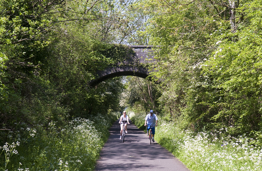
Where the M32 is the dagger thrust into the heart of the city, the Railway Path is the thread that ties the neighbourhoods of northeast Bristol together.
While London’s attention is turned to Blackfriars Bridge, those blissfully unaffected by the bumbling buffoon Boris* might like to take a look at the 45 proposals that councils around England have submitted to the DfT’s Development Pool in the hope of being picked for a share of the current £630 million available for local transport projects.
Heads of council transport departments and engineering consultancies have dusted off the bypasses, relief roads, distributors and links that they have been drawing and re-drawing, submitting and resubmitting for funding for fifty years.
Look at your local area in the Development Pool and you’ll find them all there. They’ll be called something like “town centre improvement”, “bus rapid transit”, or “cycle route enhancement and congestion relief package.”
Things like the Weston-super-Mare package, which will provide better bus services and enhanced cycle routes, by, erm, widening town centre roads and ensuring that they have substandard and probably unusable shared pavements alongside.
Of the Cross Airfield Link Road, proposed to open a large brownfield site to light industrial and retail developments,** the Weston package says:
The approval is for a single carriageway road 2.4km in length, four roundabout junctions and parallel shared-use foot and cycle ways. The proposed road is 7.3m wide single carriageway. A 3.0m wide segregated shared pedestrian and cycleway will be provided along the northern side of the new road with a 3.0m footway along its southern edge. Both the cycleway and the footway will be segregated from the carriageway by 5.0m verges which are to be planted with trees to create a boulevard along the road’s length. The scheme design includes Toucan crossings in strategic locations.
This sort of stuff should be illegal — I mean that, actually legislated against. Proposing a shared pavement as a transport route in a built-up area should mean automatic rejection from the Pool, pending a suitable revised design. Three metres should be the bare minimum width requirement for a two-way dedicated cycle track on busy roads like these, where large trucks are expected, and even then the council/agency should have to provide a very good explanation for why a 4.0m track or a pair of 2.5m unidirectional tracks would be unreasonable. Weston are proposing to spend our money on a future facility of the month, and that should be against the law.
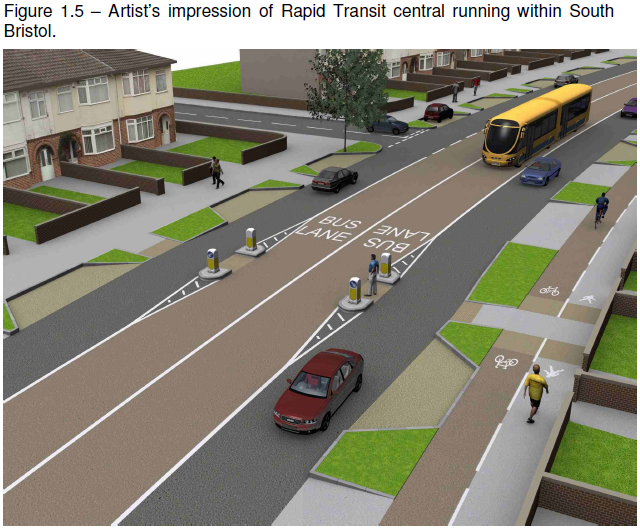
There is a pattern to the Development Pool proposals. Another Westcountry project is the “South Bristol Link”. It’s a Bus Rapid Transit route, and definitely not the South Bristol Link Road, the extension to Bristol’s southern bypass that the council has been drawing and re-drawing, submitting and re-submitting for funding since the sixties. It just happens to be a road, and to follow the route of the South Bristol Link Road. But it has bus lanes, which makes this a Bus Rapid Transit project, and definitely not the same old bypass. Bristol has grown since the road was first proposed, but the route was set aside, leaving a strip of undeveloped land surrounded by housing. Here’s the artist’s impression of the Bus Rapid Transit system:
Look at that lovely 3.0m shared pavement — in this case divided into equal shares of 1.5m footway and 1.5m bidirectional cycle track. Doesn’t it look so inviting, riding against traffic, alongside the car parking bays, in a space barely wide enough for one bicycle. One bicycle is presumably all that the council are expecting: there is no provision for two bicycles travelling in opposite directions, or travelling in the same direction at different speeds. The council will no doubt seek a solution to that problem if and when it ever arises.
It’s a classic British road mockup. Hide all the cars and clutter and put unnaturally large pedestrians and cyclists in the foreground. The road would be carrying thousands of vehicles per day, swelling with induced demand, but here it’s all free flowing, and just a single homeowner parks a car in their neat free parking bay, gift from the council. Perhaps all the other cars are parked in the city centre because neither a 1.5m bicycle track nor a bendy bus to an edge-of-town park and ride interchange are attractive methods of getting to work?
A 1.5 metre bicycle track will be of no use to anybody. The parking bays will, if you let them, fill with second and third cars, and spill out over the drop kerbs and green spaces. Within a few years the city will discover, to everybody’s surprise, I’m sure, that there is limited demand for a bus between suburban housing and an edge-of-town park and ride interchange, and the bus lanes will quietly be turned into general traffic lanes.
I’m really quite embarrassed for Bristol, having praised them for exceeding our (low) British expectations on Redcliffe Bridge. Seriously, what the fuck, Bristol? “The country’s premier national and international showcase for promoting cycling as a safe, healthy and practical alternative to the private car for commuting, education and leisure journeys.” Bristol’s “cycling city” status clearly hasn’t really sunk in for the highways engineers, who plainly have no experience of cycling or how to provide for it, but who confidently give it a go anyway having read something once in an instruction book.
The city council are cutting hundreds of jobs, and I think I’ve spotted where a few of them of them could go.
While cutting those jobs, the city is seeking £43 million for this bypass Bus Rapid Transit line. I think the Cycling City team could use the money far more profitably, retrofitting the city’s existing big roads with wide, fast, direct, prioritised, attractive tracks, and could never support Bristol throwing the money away on the South Bristol Link. But even for an urban road project, and even leaving aside the contemptible crap cycle facilities, this is an especially bad scheme. The one potential benefit of a bypass is to have a designated road on which to push traffic from city streets. But to capture that benefit you have to reclaim those city streets immediately — make it unattractive to drive on them for anything other than essential property access and loading — otherwise people will just find new ways to fill the old streets with more ridiculous car journeys. With a southern bypass Bristol could close ratruns through the southern suburbs; take back space on the main southern arterial roads — the A38 through Bedminster, for example — for the pedestrians and cyclists who spend more money in the shops along them; it could even close some more of the inner ring road. Bristol failed to capture those benefits when it previously built big bypass roads, on the northern and eastern fringes, and it would fail to capture any potential benefits of a southern bypass, proposing to make it a little bit less attractive to drive only on a couple of residential streets and a country lane:
* but we’re all affected, sadly, due to London’s unfortunate influence over the nation.
** it’s actually one of the least indefensible of the new roads, and one of the least bad sites for such developments, being on brownfield located alongside a railway and within walking and cycling distance of the town’s population and railway stations. I’m sure they will fail to make good use of all that potential, but it’s still progress over road-only out-of-town greenfield sprawl.
Like most British cities, Bristol has a big inner ring road. It crashes through neighbourhoods of medieval houses and 1970s concrete office towers, and it thunders past landmarks from Brunel’s Temple Meads Station to England’s largest parish church, St Mary Redcliffe, a fortress of fast cars and pedestrian cages cutting the old central business district from the rest of the city.
But it’s not a ring road. The ends used to meet: from Redcliffe church it continued west over the bascule bridge and cut diagonally through the run-down Georgian Queen Square. Twenty years ago, Queen Square was taking 20,000 vehicles a day, including 1,000 buses. No wonder it was run-down. The council got rid of the vehicles, all of them, and restored the Georgian square, now a calm but popular little park. It remains one of the few notable examples of undoing 1950s-80s urban motorway mistakes in the UK, and it happened at the same time as one of the last of the mistakes, the M11 link, was being driven through Leytonstone.
The restoration of Queen Square left a bizarre stub of dual carriageway on Redcliffe’s bascule bridge (orange, below the ‘I’ in ‘Bristol’), carrying a tiny fraction of its designed capacity. When I was there in the spring I noticed that they had finally brought the builders in to do something new with the bridge. Here’s the finished £130,000 piece:
I was a bit disappointed — I’d been expecting them to move on to the other carriageway once this one was complete, for a pair of unidirectional tracks, but they’ve just gone for a bidirectional track using a single traffic lane, which apparently isn’t much help to the gentleman who is using the opposite pavement. Still, the one track is not an unusable width.
The reason they’ve gone for a two-way track here is that the council are not thinking in terms of fixing individual isolated streets, but nor have they yet got to the stage where they can think in terms of a network. If this were part of a network, you would have tracks on each side linking up to more tracks around the other big roads, as well as to the calmed low-traffic streets around here. Rather, Bristol is currently thinking in routes — that’s all they can do with the small pot of money they were given to become a “cycling city”. This is one of half a dozen routes that the city was able to create with the project.
It’s the “Brunel Mile”, a very direct route between Temple Meads Station to the bars, restaurants, and museums of the old harbour. Sadly, this short section over the bridge is probably the highest quality section. The cycling city website, Better By Bike, produced a video of it:
Lots of shared use plazas, parks, and pavements. That’s fine for access — making it possible to keep riding the final yards to the destination — but shared use doesn’t really make for an attractive through route, especially when it runs straight through a set of tables laid outside a cafe. Bristol already had a lot of shared use squares and parks — Bristolian pedestrians and cyclists seem to be able to get along without one interpreting the mere sight of the other as a near death experience. Little, if any, of the shared use in this video is new, but previously it was designated as shared use more because there was no reason to ban bicycles from those areas, rather than because they made useful through routes.
Bicycles have at least been given priority, and a raised table, where the route crosses Welsh Back, from Queen Square onto the bascule bridge — though there aren’t many other examples of this arrangement in the Westcountry, so it might take motorists a while to work out that their “give way” markings aren’t a mistake (notice that the producer of the video clearly had little confidence that the white van was going to give way at 0:57). And there’s no other priority crossings on the route — only some grey-green paint on Prince’s Street, and toucan crossings with very long waits on three different branches of ring road before finally reaching Temple Meads.
This is not a toucan.
Clearly the cycling city team were going for a cheap option — spreading their little grant thin over as many routes and projects as possible, and reusing as much existing infrastructure, whatever the quality, where they could. But when it came to a gap in their route, where no existing infrastructure could be commandeered, they’ve taken the time and money to do it right: they’ve taken a traffic lane out to built a proper usable cycle track, rather than dump people on a dual carriageway with the buses. Perhaps it’s not quite as much space as would really be desirable, but it’s enough, and with priority over the minor roads. And they did it, so far as I can tell, without being asked — without the campaign and the fight that was required in Camden.
With real funding, I think Bristol could do great things. The cycling city grant must have brought some of the right people in. With the grant all spent, I fear they will have been sent on their way.
The local rag doesn’t like it, but I always got the impression that the Evening Post was pretty irrelevant.